
Over the course of one weekend in mid April the landscape of the Murchison Region was entirely transformed. After a long five months with no rain, there was a buzz in the air and sense of excitement amongst pastoralists at the possibility of some precipitation on the horizon.
We arrived at Wooleen Station on the Friday morning. After checking in at the homestead and catching up with Frances one of the owners, we set up camp at Rocky Outcrop campground and headed out to explore the landscape that had so captivated us on our last visit.
Our last stay at Wooleen in September of the previous year had coincided with the peak of the Western Australia wildflower season. The spring brings with it an abundance of native flowering plants and plethora birdlife. It was after experiencing this avian spectacle that I discovered my new love of ornithology.

At the time Wooleen Lake was dry but alive with native grasses and tiny little orchids. Yewlands Pool was a watery sanctuary brimming with water birds and rimmed with wildflowers as far as the eye could see. Gradagullya Pool, a near-permanent pool in the Murchison River was a welcome oasis retreat in the otherwise dry riverbed.
Now, at the antipodal point of the dry season, the outlook was much changed. The still-dry Wooleen Lake had been home to the small herd of cattle that roam the vast property and the grasses grazed much lower than before. Yewlands Pool was desert of the once thriving wetland system. Even Gradagullya Pool had been dry for some time – a rare occurance.
Despite the change in climate and vegetation, the station retains its outback charm. It is rewarding to see the land in a new season and gives us much appreciation for the abundance of life that comes in spring.
A bleak forecast
Prior to arriving had Frances messaged to let us know the potential for a wet weather forecast. We were still welcome to visit but needed to be aware that roads may be closed if they become impassable. All roads leading to Wooleen are wide, well maintained dirt roads, and often quite comfortable to drive on. Bridges are not built across every river or stream crossing, instead the road passes through ‘floodways’, depressions where the rivers cross the road. Ordinarily, this is not an issue. It is only a few times a year after heavy rain that water flow over these crossings can reach several metres deep. The forecast for Wooleen Station was 20ml on the Saturday with sprinkles on the Sunday.
The other reasons roads can be closed is that driving on wet dirt roads causes damage that is time consuming and expensive for the shire to repair.
We had planned a two-night stop over at Wooleen en route to Mount Augustus and Kennedy Range National Parks. Having plenty of time, freedom and an unquenchable thirst for adventure, we decided to head to Wooleen Station regardless and go with the flow.

Returning to our favourite outback station
Our first foray around the station on the Friday afternoon revealed signs of some recent precipitation; just a few damp spots on the road out to the Murchison River.
We had the privilege of being the first guests to arrive after Wooleen Station formally opened for the tourist season, and were the only guests on site. Because of this we decided to check out the other campsite along the banks of the Murchison River. To respect the privacy of other campers, we had not ventured out this way on our previous visit.
The large and widely spaced sites are perched right on the lip of the 3-4m high banks on the outside of the river bend. Stunning as these campsites are, we adore our secluded Rocky Outcrop campsite for peace of mind when camping with a toddler.
The Murchison was completely dry save for a few small ponds.

The first rains
Saturday morning greeted us with the first true rains of the season. We woke early to big, heavy drops landing on the roof of our camper trailer, and the occasional drip blowing in through the fly screen to land on our faces. We dashed out of bed to shut all the window awnings.
The Rocky Outcrop campsite is nestled in the apex of a sweeping 3m high craggy cliff face and set upon a wide, flat sandy plane. The track into the campsite crosses a small dry stream gully.

After only 20 minutes of moderate rainfall we began to see the myriad of small waterways take form. At every few metres along the outcrop wall drips and dribbles formed tiny waterfalls, which flowed into a small depression that ran along the outskirts of our campsite. From there the water flowed into a main channel and away to some far-off place.
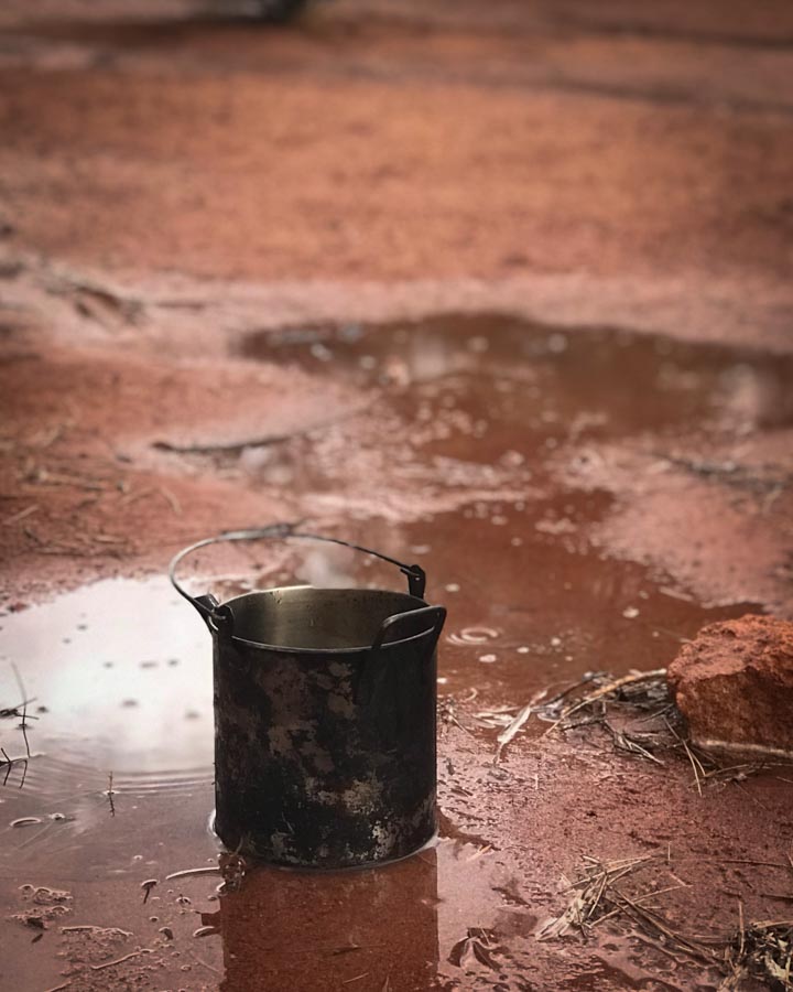
Rain does not put a dampener on things when camping with a toddler: Maddie had a wonderful time running through the little stream, jumping and splashing. She carried the billy filling it with water and rocks before depositing her collection into another puddle.
Within an hour of that first rainfall, the whole campsite was dry again. We set off the homestead to get the latest weather report.
A change of plans
The rest of the day passed without much more rain and turned out to be a lovely sunny day. However, the region to the north of us had received a lot of rain, closing the road north and blocking our path towards Mount Augustus and the Kennedy Ranges. The updated forecast was for Wooleen to receive heavy rain the next day. We again had the choice to leave then and take advantage of the open roads south back in the direction in which we had arrived, or take our changes staying.
We stayed on at Wooleen and oh boy, are we glad we did! The ecological and meteorological wonder that followed was a vision that few are blessed to witness.
Thunderbolts and lightning, very, very frightening
Neither of us had ever experienced anything other than hot, sunny days in the outback while camping. We tend to head in the opposite direction of bad weather. However, with two weeks of supplies and not much chance of reaching our intended destination due to road closures, we wanted to witness a true outback lightning show. The storm of the Saturday night did not disappoint.

From dusk, the clouds started to roll in. Although we got very little rain, the sky lit up in a thousand flashes, illuminating the landscape as if it were daytime. We drove to the entrance of our campground and parked atop a small hill so we could watch the storm pass over the sweeping vista of Wooleen Lake in the distance. We counted lightning strikes every 10 seconds or so. I set up my tripod across my lap in the passenger side of car and sat back (rather uncomfortably) while the camera snapped away. I would have liked to get out and set up the tripod from one of the outcrops but did not relish the idea of being the only elevated thing, holding onto a metal tripod, for a dozen kilometres in any direction, in the middle of a lightning storm. We watched the far off communications tower receive multiple direct strikes in the short time we were watching.
Returning to our camper trailer, we snuggled up for a relaxing evening listening to rain and thunder – Mother Nature’s sound track.

Awaking to a different landscape
We awoke on the Sunday to a much wetter land. Attempting to drive to the homestead for an update we decided to turn back at the first gate, taking a short side track and bogged the car in the sticky mud. Lesson learned – don’t ever drive on dirt roads after a storm!
After a few hours and a gallant effort by Jed to free us, we decided to walk the 5km back to our campsite. Our precocious two year old Maddie loved the walk! She bounced along the whole way, jumping in puddles and throwing rocks in to create splashes and ripples. Most of the track was now half a foot deep in water. We walked most of the way barefoot, donning our thongs only when we needed to pass over some spiky bushes.
We stayed put at our campsite until David, our Knight in Shining Ute, towed the stricken car out the next day.

What a difference a day makes
Being restricted to our campsite was not a bad thing. In the breaks between downpours we explored the boulders and crevices, following the temporary waterways and watching in wonder as each dried up within a few hours.
David had told Jed that the Murchison was now flowing and the road out to it was no longer under water. We hopped in the car and headed off to see for ourselves.
The difference between Friday and Monday was beyond comprehension. I had heard that the river can change its character quickly, but might not have believed it myself had I not seen it with my own eyes.

We pulled into the small parking area and could see water shimmering through the bushes. It was immediately apparent why the small turning area was set back so far from the river. On our previous visits we had walked a hundred metres down to the riverbanks and then 20 minutes down to dry channel to Gradagullya Pool.
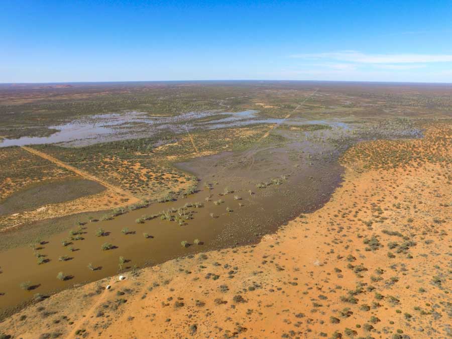
Now it only took a minute to reach the waterline. The muddy water encroaching the sandy banks and tree trunks submerged easily a metre or so where we had previously walked. It was not easy to discern the riverbanks at this location. When dry this system shows several channel features nested within each other, rather like a Russian doll, demonstrating different water levels. This day every one of them was submerged. Still, above us river flow sand dunes are apparent to the trained geographer meaning the river can still reach a higher level – and was indeed still rising.

Flow in the centre of the channel was powerful, carrying large branches and debris along with the fast current. This would not be a great day for a swim and we kept a close eye on our daughter around the murky water.
We estimated the river to be around 60m wide from where we were standing. It wasn’t until Jed launched the drone that we could see flooding beyond the far tree line for dozens of metres further. At a rough guess, the width of the Murchison River could be as much as 130m.
From above, the main channel was clearly defined and lined with large gum trees with extensive flowing beyond. What a difference from dry only two days previously!

This part of the Murchison fills not from rain that fell on Wooleen Station itself, but from neighbouring Meeberrie Station to the north. It takes two days for water that fell on Meeberrie to reach here.
Just upstream from us we could see David’s Envirolls doing their job, catching debris in the flow to form small dams and slow down the current; replicating the role of denser vegetation that would have been present prior to intensive farming over the past century. Conservation and land regeneration are at the core of David and Frances ethos towards sustainable agriculture and eco-tourism; a philosophy I am fully behind and proud to have witnessed the results of over our several visits. You can read more about their story here.

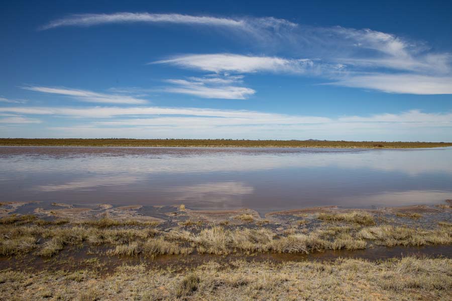
Wooleen Lake – Tuesday morning
We have only ever seen Wooleen Lake without water, as would have almost every other visitor to the station. The lake only fills around once every 9 years! In the years between it forms an extensive grassy plane. Following all the rain around the region Frances hinted that it mightfill. We were keen to have a look!
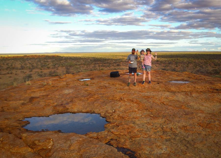
Knowing the roads were not suitable to drive down we chose to hike one of the fascinating walk trails from the homestead. Walk Trail 2 passes by the original homestead and well, mounts of rusty old tin cans and glass medicine bottles, and a number of other reminders of Wooleen’s history. Taking the extended hike leads you right to The Picnic Table, a romantically secluded picnic spot in the shade of a gum tree on the shore of the lake.
Although the trail out to the lake was saturated, and often and inch or so deep in water, the lake itself showed no signs of filling just yet.
It is not unsurprising to find the Murchison River so exuberantly overflowing yet the lake, just a few km away dry. Wooleen Lake fills from a different source: the Roderick River to the southeast. The water that collects here fell much further away and takes an extra day or so to arrive. Everyone was excited to see what the next few days would bring.

Wednesdays Watery Wonderland
Wednesday morning greeted us with another delightfully sunny day and a few dry tracks more suitable for driving. We checked in at the homestead to the exciting news that water was now flowing through The Channel and was rapidly pooling in the Wooleen Lake.
Frances marked the passable tracks on a map and pointed us in the direction of the best viewing areas. Cautiously, we headed out, careful not to get bogged (again).
The Channel was not just flowing, but overflowing and covering the track! We drove as far as was safe and got out to admire our new surroundings. Already the air was filled with butterflies and dragonflies. It is incredible how quickly nature responds to a good rain.
From our vantage point we could see the lake was starting to fill. Again, we did not fully appreciate the vast magnitude of the watery expanse until we launched the drone. I would not attempt to guess how many acres the lake now covered, but it was a lot; perhaps the size of a suburb.

Yewlands Pool
The incredibly serene Yewlands Pool that had been home to so many birds on our visit the previous year was dry and quiet when we returned on Friday. By Wednesday morning it was no longer an isolated pool but a southern extension of Wooleen Lake. All of the tracks out to Yewlands Pool were now underwater but we were able to drive up a back route from the main road right up to the water line.

Trees that were once set several metres back from the pools edge were now at least a metre deep in water. Amazingly, much of the birdlife had already returned, again striking me with awe at how fast nature can respond.
Only three days after the rain bright green grass shoots were sprouting all around the pools edge. We did not explore far from the car, cautious not to disturb any of this new growth.
The soil must be saturated with seeds and dormant plants just waiting for the right conditions to spring to life. Mosses and various green sludge’s quickly appeared throughout the station, making walking a bit tricky over these new slippery surfaces. Again, we avoided disturbing these new growths at all costs.

A landscape transformed
Our grand road trip up north did NOT go to plan. We only got to our second stop of the five we planned, became isolated to our campground for entire days, all access roads in and our were closed and the station tracks impassable for much of the time. We even got the car bogged and had to walk the 5km back to our camper trailer. And yet, even with all of that, we had one of our favourite and most memorable trips.
To witness the landscape transform and come to life is an incredible and rare experience. It was coincidence that we happened to arrive just in time to see it so parched after five months of no rain, and poor planning on our part that we headed into the outback with storms forecast. And yet, we were treated to one of the grandest displays Mother Nature can offer.
Australia’s Golden Outback is ephemeral in both the geological and philosophical sense of the word. It is a desert occasionally flooded. From arid to wetland wonderland in a matter of days. It is hot, really hot, yet can be cold enough to precipitate ice, or even snow as we saw in Albany the next weekend. It is at first glance dangerous and barren, but look a little closer and be enchanted by the zebra finches, splendid fairy wrens and kingfishers. It is a harsh and unforgiving climate yet nurtures the most precious and delicate wildflowers. A land of expansive sunrises and sunsets, epic lightning storms, and where on a clear night you can see the galactic centre of our milky way sprawling across the night sky. And if you arrive at just the right time you can see all of this in one visit.
The Wooleen Way by David Pollock
Did you know that David from Wooleen has written a book all about the Wooleen philosophy. I have read and thoroughly enjoyed it. You can get your copy on the Wooleen website.


This is an amazing place! I never heard of him … Thanks for sharing. Your photos are very impressive!
Wow! Your photos are incredible! And it’s crazy how much the water makes everything look so different! It looks like a totally different place! So beautiful <3
It is so beautiful to see and read about the transformation you witnessed at Wooleen Lake. Even though you had to change plans on your trip, it’s great the region received the much-needed rain. Beautiful shots of the contrast between the before and after. Have not made it to Australia yet and hope to get there soon.
I was so humbled to see the transformation myself. It was an incredible experience! I hope you get to make it so Aus some day
What an amazing little adventure you had! I don’t know how my 2 year old would react to lightning, he hasn’t experienced it before (we don’t get too much rain here in Dubai)
Stunning pictures though 🙂
Thank you. For some reason our fearless little girl loves thunder and lightning (some of it even scared me a bit).
Australia hasn’t been on my bucket list until I watched the film Tracks where a woman travels solo in the outback. Your post reminded me so much of that! I love how you captured the dry desert blossoming with life. Your photos of the storms sweeping through the outback are magnificent! I would love to spend a week just camping in the same area and watching the storms light up the sky. So beautiful!
Oh I haven’t watched that film, I’m going to look it up and watch it tonight. Thank you for your wonderful compliments. I cannot take the credit, it is the outback that holds all the beauty and I just try and share that.I hope you add Aus (and in particular WA) to your bucket list! You won’t regret it 😀
Wow what a difference that rain made! I think I would have been worried about the rain and probably would have stayed home, and I’m so glad that you didn’t because your pictures are spectacular! I can’t imagine walking the 5km in sticky mud though.
It was only our foolishness that kept us heading into the path of a storm haha but you are right, it was absolutely worth it! Thank you xx
Such an interesting read! And your storm photos are beautiful. What a terrific experience you all had. Thank you for sharing it.
Thank you Darcy, it really was a wonderful and uplifting experience
Sounds like such a wonderful trip! Love the way you told your story! Getting to experience different sides of a place is great – what an adventure
Thank you Hayley, this was the best kind of adventure! I’d do it again in a heartbeat 😀
It’s crazy how much the landscape changes so quickly. Although there were road closures, it sounds like you still had tons of fun even with a 2-year-old 🙂 The lightning must have been so beautiful yet scary at the same time to watch.
True, it was a little scary. I did question whether or not it was safe to be sleeping in a tent with dozens of metal poles!! But we were ok 🙂
Looks absolutely wonderful! The landscape and your pictures! I can definitely imagine hiking there or taking kayak and enjoy the stream
I would love the kayak the streams! Maybe when the flow slows down a little though. It would be wonderful with all the birds arriving and flying overhead
the photo of the storm has given me goosebumps!!! amazing! x
Wow!! I just love your photos of the storm. That’s incredible how much the landscape changed in just a couple of days. Sometimes when travel doesn’t go to plan, it throws in the best adventures. 🙂 Certainly sounds like you made the most of it!
What a fantastic journey! Those storms must have been incredible. But to see the new life growing afterwards must have made it all worth it. glad you stayed safe and what an adventure!
We’ve been caught out a few times by storms while traveling, but nothing like this! Water is life, and yet, it can destroy so much too.
So true. It is the first time we have been caught in these conditions too.
What a spectacular adventure! I once got rained in in the Simpson Desert and that extended stay in the desert was one of the best parts of the entire trip! The explosion of life in the desert after a period of heavy rain is such a rare treat to witness, isn’t it?
Your image of the storm and the stars is superb!
Thank you! We would love to explore the Simpson Desert. Hopefully one day when the little ones are a bit older. I agree the explosion of life is quite incredible.
Wow! Some awesome photos! Love reading about your adventures 💗 xx
Thanks Kate, we have such an incredible time on our trips 🙂
What an absolutely fantastic story.
Thank you very very much for sharing it with us.